
![]()
![]()
![]()
![]()
![]()
![]()
![]()
![]()
![]()
![]()
![]()
![]()
![]()

![]()

![]()
![]()
![]()
![]()
![]()
![]()
![]()
![]()
![]()
![]()
| The west side of Manhattan is the location of the railroads that I intend to model. Starting at 30th street, the New York Central, The Erie Railroad, The New York Terminal Stores Building and running down to 26th street with the Lehigh Valley Railroad. This portion of New York City also was home to the Pennsylvania Railroad, and the Baltimore and Ohio. Both of these railroads also had car float operations as well. The New York Central was the most extensive of the railroads with mainline access to the bulk of Manhattan Island as well as the rest of the country. The Central also operated the High Line that replaced its street level road downtown to lower Manhattan. | |||
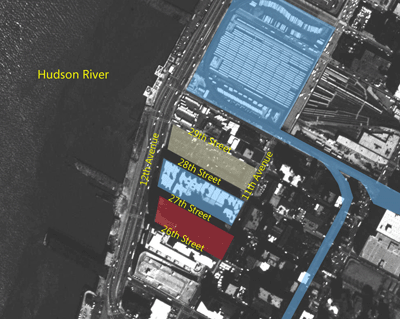 |
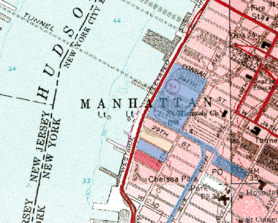
The three railroads that I'm modeling shared a connection to the New York Central's Terminal Stores Building. This Building was located on 12th Avenue between 28th Street and 27th Street. The aerial View to the left shows the New York Central's 30th Street yard and High Line, the Erie's 28th Street Yard, the New York Terminal Stores building and the Lehigh Valley. | ||
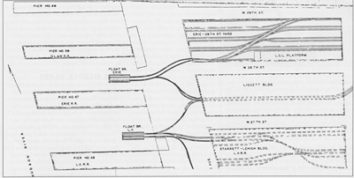
| South of the Lehigh is the B&O's yard. The B&O yard while very interesting is just out of reach for my space. Above to the left is an aerial photo of the area of interest and below to the right is a topographical map of the same region. These maps and photo are well after my operational period but dose show the physical arrangements of the yards. Most of the piers are gone by the time these maps and photos where made. The drawing below is an illustration | |||
of how the Lehigh Valley and the Erie’s tracks where laid out. Missing from the drawing is the New York Central Railroad's 12th Avenue
|
 |
||
| line. The 12th Avenue line connected the 30th Street Yard to the New York Terminal Stores Building. From the research I have done I have found that the Central use a DES-3 locomotive to handle the normal switching. The DES-3 is Tri-Powered locomotive, Battery, Third Rail, and Diesel. | |||
Page Last Updated: October 3, 2010
Webmaster: David Ramos